Wednesday, August 31, 2011

Makapu'u Light, Hawaii, HI


According to Hawaiian legend, Makapu`u was a supernatural being who, after arriving from Tahiti, took up residence on the point now bearing her name. This being's defining feature was her set of eight bright eyes, which is reflected in her name Makapu`u, Hawaiian for bulging eye. On October 1, 1909, the light from another bright, bulging eye was seen on the rocky point of Makapu`u as the giant lens in the Makapu`u lighthouse was illuminated for the first time.


A petition, calling for the establishment of a light on the point, was signed by a number of sea captains and ship owners and presented to the Hawaiian government in 1888, after the American ship S. N. Castle had run aground in the area. Many thought the grounding would have been avoided if a light had been present on Makapu`u Point. Some preliminary planning for the lighthouse had been enacted by 1901, but when the territorial government learned that the U.S. Government would soon be assuming responsibility for navigational aids in the Islands, no further work was pursued.

Makapuu Point is the extreme southeastern point of the island of Oahu. To the east of it is the Kaiwi Channel, which passes between the islands of Oahu and Molokai, which are about 25 miles apart. The harbor of Honolulu, the principal harbor of the central Pacific Ocean, is on the southern coast of Oahu, a short distance west of Makapuu Point. … There is no light on the entire northern coast of the Hawaiian Islands to guide ships or warn them as they approach those islands. The lack of such a light not only renders navigation at times very dangerous, but in bad weather or at night often compels them to slow down and await clear weather or daylight. With the increasing importance of commerce between the United States and the Hawaiian Islands, and the commerce passing the Hawaiian Islands and stopping at Honolulu, it will be very greatly to the advantage, speed, and safety of vessels that this much-needed aid to navigation be provided.


Makapu`u Point rises 647 feet above the ocean and is composed of a number of lava flows. The three keepers' dwellings, constructed of the abundant lava rock on the point, were built in a depression near the summit. At a height of 395 feet above the water, a notch, large enough to hold the lighthouse, was blasted out of the lava face. A trail linking the lighthouse and dwellings and a road connecting the station to the nearest highway had to be carved into the lava point.


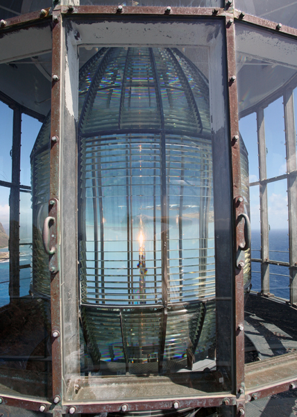
The thirty-five-foot tower was ready to receive its lens by October of 1908, but what size of lens to use in the tower was still being debated. Plans called for a third-order lens, then a second-order lens, and finally a first-order hyperradiant lens. The Lighthouse Board had purchased the 12-foot-tall lens, which had an inside diameter of roughly eight feet nine inches, in 1887. The lens was exhibited at the 1893 Chicago World's Fair, and then placed in storage for several years before being shipped to Oahu.


Hawaii's first radio beacon was installed at Makapu`u Point in 1927. The signal produced by the beacon could be picked up at a distance of two hundred miles and could be used to determine one's position. A generating plant was established on Makapu`u Point to provide electricity for the radio beacon, and the lighthouse was converted from oil-vapor to 500-watt incandescent electric lamps.


The lighthouse is owned by the Coast Guard. Nearby area open, tower closed.


Makapu`u Lighthouse, Hawaii at Lighthousefriends.com

Wawatam Lighthouse, St. Ignace, MI


This classic lighthouse started life in 1998 as a Michigan Welcome Center travel icon at Monroe, Michigan. In 2004, the Monroe Welcome Center was being revamped and the lighthouse was put up for relocation. The City of St. Ignace was the lucky recipient and the structure was trucked north in five pieces. It stayed on the Chief Wawatam Dock for a time, awaiting the construction of its new platform.


The red, white and green lighthouse was repainted in bright white with red accents. In June 2006, a crane reassembled the tower on its new site. Everything was in readiness, just waiting for U.S. Coast Guard certification.


Wawatam Lighthouse takes its name from the late railroad ferry Chief Wawatam, which used this same dock from 1911 through the mid-1980's. When you visit the lighthouse, you will pass right by the Chief's old lift gate. Wawatam Lighthouse's beacon was first lit on August 20, 2006. Visible for more than 13 miles out over Lake Huron, it is now an official aid-to-navigation. The 250 millimeter Fresnel lens casts its light in a 152 degree arc.


Though the lighthouse's GPS location is 45-051-19.700 N by 084-42-09.000 W, it will most likely be easier for you to find it straight out east of McCann Street. The Coast Guard assigned the beacon to be a white light flashing every five seconds. The tower is 52 feet tall, but the Coast Guard looks at it in a different way. They rate it as 62 feet tall from the water to the focal plane (the beacon). This lighthouse stays lit even in winter – to be a guide to snowmobiles crossing the ice bridge from Mackinac Island.


The new lighthouse in St. Ignace has been named Wawatam Lighthouse and its navigational light could be operational later this month, pending approval by the U.S. Coast Guard. Standing at the end of the old Railroad Dock, home to the rail ferry Chief Wawatam, the beacon defines the harbor and marks the entrance to the City Marina. Once lit, Wawatam Lighthouse also will serve as an aid to navigation.


A permit to turn on the light has been filed with Ninth District Coast Guard in Cleveland, said Eugene Elmer, St. Ignace marina director, who hopes to have approval to flip on the light switch by the end of the month. The Coast Guard required that the lighthouse be named before the application for the light could be processed.


To keep the process moving, a poll quickly was taken with people at St. Ignace City Hall. Wawatam was the first choice and it provided a tie to the dock's history, said Mr. Elmer. Built in the late 1800s by the Duluth, South Shore and Atlantic Railroad, the railroad dock once served as a port for the 338-foot railcar ferry Chief Wawatam. The track elevator used to align the railroad tracks on the dock with the deck on the Wawatam still stands at the base of the dock and serve as a reminder of the area's railroad and ferry history.


As the city awaits the permit approval to make the lighthouse operational, a project to extend the existing boardwalk to the lighthouse is about to go out for bids. The project will include a fishing pier on the south side of the dock near the lighthouse and a railing around the light.


Once operational, Wawatam Lighthouse will remain lit yeararound and during winters, when an ice bridge is in place between St. Ignace and Mackinac Island, the Wawatam's light may aid snowmobilers coming into St. Ignace, said Mr. Elmer.


On a clear night, the light will be visible from 13.2 miles away. Mackinac Island is approximately three miles to the east of the beacon.


Wawatam Lighthouse, St. Ignace, MI :

http://www.redbubble.com/people/papajohn/art/4138678-wawatam-lighthouse-in-st-ignace-michigan

Monday, August 1, 2011

Maine Open Lighthouse Day Set for September 17, 2011

The third annual Maine Open Lighthouse Day will take place rain or shine Sept. 17, with many of the state’s coastal, island and river lighthouses planning to welcome the public.

18,000 people visited 25 open light stations during the 2010 event, and 5,000 people climbed up light towers for the lantern room view. The event is coordinated by the U.S. Coast Guard, in partnership with the Maine Office of Tourism and the American Lighthouse Foundation, and is the largest event of its kind in the country.

Maine lighthouse fans can learn about participating lights and share their Lighthouse Day plans on the new event Facebook page at www.facebook.com/MaineOpenLighthouseDay.

Most lights will be open to visitors from 9 a.m. to 3 p.m. for guided or self-guided tours of keeper’s houses and light towers. Some light stations will have limited accessibility or special restrictions. For details about visitor hours, fees, activities and transportation to each participating lighthouse visit www.lighthouseday.com or contact the friends group of an individual light.

More than half of the 60-plus working lighthouses in Maine are accessible to the public during the summer months thanks to the landmark Maine Lights Program passed by Congress in 1996.

This program transferred the ownership of lighthouses from the Coast Guard to local preservation groups and organizations like the American Lighthouse Foundation, and served as a model for the National Historic Lighthouse Preservation Act of 2000.