Tuesday, March 26, 2013

Lighthouses All Lit Up


Tuesday, February 14, 2012

Beacons of Valentine's 2012


In the event of Valentine's Day.. I have dedicating this post to all Lighthouses whose I am surprised is not able to find one with a single Heart upon it, although for as much as I know.. there are none (that I know of) that are in any shade of pink, unless otherwise made to seem that way. By the way, in any event, red wins by a longshot. Therefore, it was in my admiration to present to you some awe-some Lighthouses.


Blessings Abundant,

Robin Ann


Monday, September 19, 2011

Lighthouse At Europa Point, Gibraltar


Of the three attractions of Europa Point, the one which is most often visited and most frequently commented on, in fact one of the most well known of all the attractions of Gibraltar, the Trinity Lighthouse, or the Lighthouse at Europa Point must take that prize.


The actual construction of the Lighthouse at Europa Point was begun in 1838, by the Governor Alexander Woodford, who with his own hand laid the foundation for the lighthouse, setting the first stone of what would be the Lighthouse of Europa Point into place. There was a brief ceremony there, to commemorate it, which was covered by the local newspaper of Gibraltar, but actual opening of the lighthouse didn’t take place for about three more years, when it opened in August of 1841.

The opening of the Trinity Lighthouse at Europa Point was quite a spectacle, drawing in more than 2000 people from the area who came to watch its first emission of light out over the waterways. Not surprisingly, the Lighthouse was a welcome addition to Gibraltar to the sailors both local and from a distance. The Rock of Gibraltar was well known for the difficulties that could present themselves when navigating Gibraltar Bay, and any means to light the path was welcomed.


There was also a fog horn installed that would provide the ships with two short harsh blasts. In 1956, the Europa Point Lighthouse again had some positive changes to its lighting and its surface, with the installation of the more modern methods of lighting. With these additions, the lighthouse at Europa Point became more electrical in nature, and additionally the advances permitted full revolutions and had far more power and visibility than the lighthouse could previously manage.

The Trinity Light house,the Lighthouse at Europa Point began as a way to save lives and property, and to safeguard the travelers of the area, and continues to do so, yet it has evolved also to be one of the main tourist attractions of Gibraltar, has offered a means to navigate the area, to the seafarers of Gibraltar for more than a hundred years. While you’re in Gibraltar, make sure that you navigate up to Europa Point and take a look at the Lighthouse of Europa Point.


Gibraltar Rock Tours:

http://www.gibraltarrocktours.com/europa-Point.html

Thursday, September 8, 2011

Light News

Fairport Harbor West Breakwater Light sold to the next highest bidder

http://news-herald.com/articles/2011/08/05/news/doc4e3c3043b4f96245155801.txt


Tours of Erie's Land Lighthouse to be offered
The public will have a rare chance to explore the Erie Land Lighthouse during guided tours beginning later this month, thanks to a joint project by the Erie Port Authority and the Erie Playhouse.

http://www.goerie.com/apps/pbcs.dll/article?AID=/20110806/NEWS02/308059912/-1/newssitemap


Historic Lens to return to Lorain


The lighthouse lens that once helped guide ships into the Port of Lorain is closer to getting a permanent home.

http://morningjournal.com/articles/2011/08/10/news/mj4894389.txt?viewmode=fullstory


Makeover complete for Buffalo's 1833 Lighthouse


Restoration work is finished on a historic lighthouse erected on Buffalo's Lake Erie waterfront during the early years of the Erie Canal.

Buffalo's 1833 lighthouse has undergone about a half million dollars in renovations in recent years. The 44-foot-tall, octagon-shaped structure is located on a point of land next to a U.S. Coast Guard station, but has been leased to the Buffalo Lighthouse Association for nearly 20 years. The group has raised most of the funds used to maintain and restore the lighthouse.

http://online.wsj.com/article/APa91156b6eda44be298316c9376d06107.html


Some damage at Cape Lookout Light in NJ from Hurricane Irene, and other units, lighthouses with varying degrees of damage

See National Parks Traveler for full coverage of all Lighthouses damage and recovery stories:

http://www.nationalparkstraveler.com/2011/08/updated-cape-lookout-national-seashore-heavily-damaged-hurricane-irene-other-units-have-varying-degr870


LighthouseFriends.com Posters:
http://lighthousefriends.com/posters.html

Wednesday, August 31, 2011

Makapu'u Light, Hawaii, HI


According to Hawaiian legend, Makapu`u was a supernatural being who, after arriving from Tahiti, took up residence on the point now bearing her name. This being's defining feature was her set of eight bright eyes, which is reflected in her name Makapu`u, Hawaiian for bulging eye. On October 1, 1909, the light from another bright, bulging eye was seen on the rocky point of Makapu`u as the giant lens in the Makapu`u lighthouse was illuminated for the first time.


A petition, calling for the establishment of a light on the point, was signed by a number of sea captains and ship owners and presented to the Hawaiian government in 1888, after the American ship S. N. Castle had run aground in the area. Many thought the grounding would have been avoided if a light had been present on Makapu`u Point. Some preliminary planning for the lighthouse had been enacted by 1901, but when the territorial government learned that the U.S. Government would soon be assuming responsibility for navigational aids in the Islands, no further work was pursued.

Makapuu Point is the extreme southeastern point of the island of Oahu. To the east of it is the Kaiwi Channel, which passes between the islands of Oahu and Molokai, which are about 25 miles apart. The harbor of Honolulu, the principal harbor of the central Pacific Ocean, is on the southern coast of Oahu, a short distance west of Makapuu Point. … There is no light on the entire northern coast of the Hawaiian Islands to guide ships or warn them as they approach those islands. The lack of such a light not only renders navigation at times very dangerous, but in bad weather or at night often compels them to slow down and await clear weather or daylight. With the increasing importance of commerce between the United States and the Hawaiian Islands, and the commerce passing the Hawaiian Islands and stopping at Honolulu, it will be very greatly to the advantage, speed, and safety of vessels that this much-needed aid to navigation be provided.


Makapu`u Point rises 647 feet above the ocean and is composed of a number of lava flows. The three keepers' dwellings, constructed of the abundant lava rock on the point, were built in a depression near the summit. At a height of 395 feet above the water, a notch, large enough to hold the lighthouse, was blasted out of the lava face. A trail linking the lighthouse and dwellings and a road connecting the station to the nearest highway had to be carved into the lava point.


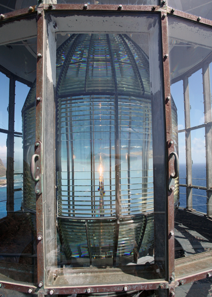
The thirty-five-foot tower was ready to receive its lens by October of 1908, but what size of lens to use in the tower was still being debated. Plans called for a third-order lens, then a second-order lens, and finally a first-order hyperradiant lens. The Lighthouse Board had purchased the 12-foot-tall lens, which had an inside diameter of roughly eight feet nine inches, in 1887. The lens was exhibited at the 1893 Chicago World's Fair, and then placed in storage for several years before being shipped to Oahu.


Hawaii's first radio beacon was installed at Makapu`u Point in 1927. The signal produced by the beacon could be picked up at a distance of two hundred miles and could be used to determine one's position. A generating plant was established on Makapu`u Point to provide electricity for the radio beacon, and the lighthouse was converted from oil-vapor to 500-watt incandescent electric lamps.


The lighthouse is owned by the Coast Guard. Nearby area open, tower closed.


Makapu`u Lighthouse, Hawaii at Lighthousefriends.com

Wawatam Lighthouse, St. Ignace, MI


This classic lighthouse started life in 1998 as a Michigan Welcome Center travel icon at Monroe, Michigan. In 2004, the Monroe Welcome Center was being revamped and the lighthouse was put up for relocation. The City of St. Ignace was the lucky recipient and the structure was trucked north in five pieces. It stayed on the Chief Wawatam Dock for a time, awaiting the construction of its new platform.


The red, white and green lighthouse was repainted in bright white with red accents. In June 2006, a crane reassembled the tower on its new site. Everything was in readiness, just waiting for U.S. Coast Guard certification.


Wawatam Lighthouse takes its name from the late railroad ferry Chief Wawatam, which used this same dock from 1911 through the mid-1980's. When you visit the lighthouse, you will pass right by the Chief's old lift gate. Wawatam Lighthouse's beacon was first lit on August 20, 2006. Visible for more than 13 miles out over Lake Huron, it is now an official aid-to-navigation. The 250 millimeter Fresnel lens casts its light in a 152 degree arc.


Though the lighthouse's GPS location is 45-051-19.700 N by 084-42-09.000 W, it will most likely be easier for you to find it straight out east of McCann Street. The Coast Guard assigned the beacon to be a white light flashing every five seconds. The tower is 52 feet tall, but the Coast Guard looks at it in a different way. They rate it as 62 feet tall from the water to the focal plane (the beacon). This lighthouse stays lit even in winter – to be a guide to snowmobiles crossing the ice bridge from Mackinac Island.


The new lighthouse in St. Ignace has been named Wawatam Lighthouse and its navigational light could be operational later this month, pending approval by the U.S. Coast Guard. Standing at the end of the old Railroad Dock, home to the rail ferry Chief Wawatam, the beacon defines the harbor and marks the entrance to the City Marina. Once lit, Wawatam Lighthouse also will serve as an aid to navigation.


A permit to turn on the light has been filed with Ninth District Coast Guard in Cleveland, said Eugene Elmer, St. Ignace marina director, who hopes to have approval to flip on the light switch by the end of the month. The Coast Guard required that the lighthouse be named before the application for the light could be processed.


To keep the process moving, a poll quickly was taken with people at St. Ignace City Hall. Wawatam was the first choice and it provided a tie to the dock's history, said Mr. Elmer. Built in the late 1800s by the Duluth, South Shore and Atlantic Railroad, the railroad dock once served as a port for the 338-foot railcar ferry Chief Wawatam. The track elevator used to align the railroad tracks on the dock with the deck on the Wawatam still stands at the base of the dock and serve as a reminder of the area's railroad and ferry history.


As the city awaits the permit approval to make the lighthouse operational, a project to extend the existing boardwalk to the lighthouse is about to go out for bids. The project will include a fishing pier on the south side of the dock near the lighthouse and a railing around the light.


Once operational, Wawatam Lighthouse will remain lit yeararound and during winters, when an ice bridge is in place between St. Ignace and Mackinac Island, the Wawatam's light may aid snowmobilers coming into St. Ignace, said Mr. Elmer.


On a clear night, the light will be visible from 13.2 miles away. Mackinac Island is approximately three miles to the east of the beacon.


Wawatam Lighthouse, St. Ignace, MI :

http://www.redbubble.com/people/papajohn/art/4138678-wawatam-lighthouse-in-st-ignace-michigan

Monday, August 1, 2011

Maine Open Lighthouse Day Set for September 17, 2011

The third annual Maine Open Lighthouse Day will take place rain or shine Sept. 17, with many of the state’s coastal, island and river lighthouses planning to welcome the public.

18,000 people visited 25 open light stations during the 2010 event, and 5,000 people climbed up light towers for the lantern room view. The event is coordinated by the U.S. Coast Guard, in partnership with the Maine Office of Tourism and the American Lighthouse Foundation, and is the largest event of its kind in the country.

Maine lighthouse fans can learn about participating lights and share their Lighthouse Day plans on the new event Facebook page at www.facebook.com/MaineOpenLighthouseDay.

Most lights will be open to visitors from 9 a.m. to 3 p.m. for guided or self-guided tours of keeper’s houses and light towers. Some light stations will have limited accessibility or special restrictions. For details about visitor hours, fees, activities and transportation to each participating lighthouse visit www.lighthouseday.com or contact the friends group of an individual light.

More than half of the 60-plus working lighthouses in Maine are accessible to the public during the summer months thanks to the landmark Maine Lights Program passed by Congress in 1996.

This program transferred the ownership of lighthouses from the Coast Guard to local preservation groups and organizations like the American Lighthouse Foundation, and served as a model for the National Historic Lighthouse Preservation Act of 2000.

Monday, April 11, 2011

Friday, April 8, 2011

Shine

by Robin Ann


The beacon of Light navigates guidance.

To distant fog whispering in.

Upon the capsized ocean waves.

Sheltered by its only fear.

To draw midnight in.

~~~~~~~~~~~~~~~~~~~~~~~~~~~~~~~~~~~~~~~~

Silent clearing the drifting tides.

Across the soon to become morning.

Searching the horizon, full circle.

As brisk the humble winds calm.

Enlighten! It's illuminating hope.

~~~~~~~~~~~~~~~~~~~~~~~~~~~~~~~~~~~~~~~~

How the shoreline waits patiently.

The lighthouse beams Her radiant Light.

For miles between all shadows lay.

And thrive the lens rest assured.

Shine on! It's strength to comfort the weak.

~~~~~~~~~~~~~~~~~~~~~~~~~~~~~~~~~~~~~~~~~

For the vessel sails on and on.

Unto the great blue sea's horizon.

In victorious glory of its grace.

Without fading of Her endless glow.

The beacon, as with all of we, Shine.

Tuesday, March 23, 2010

Science Makes a Better Lighthouse Lens


State of the art, one of the seven wonders of the Ancient World, the great lighthouse of Alexandria, built around 280 B.C., towered some 450 feet above Egypt's greatest harbor. At that height, it was the second tallest structure in the world, after another of the seven — the Great Pyramid of Giza. The light within, also state of the art, was an open flame.


From that time until the 18th century, the lights that warned ships that they were approaching land improved hardly at all. Some burned coal. Others stuck with wood. Oil lamps backed by mirrors eventually offered a bit more candlepower. Still, every coastline in the world remained littered with the ribs of broken ships whose captains didn't see the lighthouse until it was too late. Then, in 1822, a frail scientist with a passion for optics made a revolutionary breakthrough. His name was Augustin Jean Fresnel.


An example of his greatest creation, a large object that looks like a crystalline beehive, may be seen inside the Hall of American Maritime Enterprise at the National Museum of American History. It towers above the museum's displays of ship models and marine artifacts. This is the Fresnel lens, not one lens really, but numerous tiers of prisms. Lenses like this one turned simple flames into beams upon which sea captains could take their bearings, avoiding risk to their ships and to the lives of their passengers.


As big as it seems, by lighthouse standards the Smithsonian glass beehive is just above average, measuring nearly six feet high and more than three feet wide. It was installed in the famous Bolivar Lighthouse overlooking Galveston, Texas, sometime around 1907. This lighthouse served as sentry, and for some as sanctuary, during the deadliest hurricane in American history. The lens is visible proof that unlike the sea, light can be mastered by human ingenuity.


For thousands of years, lighthouses created their lights with open flames which, naturally, were ineffective during high winds or rain. Then, in the 1690s, the glass lantern room was invented and first installed in England's Eddystone Lighthouse. Candles placed in the lantern room's glass lantern burned more brightly and securely than the earlier open fires. Another improvement came when pieces of mirrors placed in huge, round, wooden bowls served as crude reflectors that helped to direct the light. But throughout the 18th century, as maritime traffic increased, shipwrecks multiplied. The search was under way for a stronger, more reliable light.


There is some controversy over who first placed parabolic mirrors behind flames to boost candlepower. L. Reynaud, an 18th-century chronicler and public works official, credited Swiss scientist Aimé Argand with the first installation of an apparatus using reflectors, in 1783. Argand also invented, in the 1780s, a long-burning smokeless oil lamp that removed the necessity of stoking the flames all night. But the greatest innovation was to come from Augustin Fresnel.
As a child, he was a slow learner who showed little interest in language studies or in tests of memory. By the age of 8, he could barely read. Yet his boyhood friends, for whom he studiously determined how to increase the power of popguns and bows, called him "the genius." When applied to optics, his genius proved to be real and considerable. Where others had improved existing lighthouse technology, Fresnel leapt forward by studying the behavior of light itself. His studies both advanced the understanding of the nature of light and produced the most important breakthrough in lighthouse lights in 2,000 years.


Fresnel worked out a number of formulas to calculate the way light changes direction, or refracts, while passing through glass prisms. Working with some of the most advanced glassmakers of the day, he produced a combination of prism shapes that together made up a lens. The Fresnel lighthouse lens used a large lamp at the focal plane as its light source. It also contained a central panel of magnifying glasses surrounded above and below by concentric rings of prisms and mirrors, all angled to gather light, intensify it and project it outward.


The various reflector systems installed in lighthouses during the 40 years preceding the introduction of the Fresnel lens certainly had been improvements over the open fires or candles in lantern rooms. Still, they could trap only a small percentage of the light. All prior systems paled by comparison with the Fresnel lens.


The first Fresnel lens, installed in the elegant Cardovan Tower lighthouse on France's Gironde River in 1822, was visible to the horizon, more than 20 miles away. Sailors had long romanticized lighthouses. Now scientists could rhapsodize, too. "Nothing can be more beautiful than an entire apparatus for a fixed light," one engineer said of Fresnel's device. "I know of no work of art more beautifully creditable to the boldness, ardor, intelligence, and zeal of the artist."


Fresnel lenses soon shone along the ragged coastlines of Europe, but surprisingly, America was slower to see the light. As mariners came to depend on Europe's powerful new lights, they complained bitterly about the puny lamps lighting America's coasts. Despite the clear superiority of Fresnel lenses, the parsimonious bureaucrat in charge of federal lighthouses, Stephen Pleasanton, considered the cost prohibitive. Finally, the uproar became so great that in 1838 Congress launched an investigation. It was not until then that Congress coughed up the cash to import a few Fresnel lenses.


Only after 1852, when the United States created a Lighthouse Board made up of eminent scientists and mariners, including Joseph Henry of the Smithsonian and Alexander Bache of the U.S. Coast Survey, did the great lenses really begin to light America's coastline. By the Civil War, nearly all lighthouses in the United States had Fresnel lenses. It was shortly after the Civil War, however, before a beehive of prisms first shone from the Bolivar Light watching over Galveston. A Fresnel lens, similar to the one on display at NMAH, was still in use there in September 1900, when waves from the Gulf of Mexico began pounding the coast.


Late in the morning of September 7, the U.S. Weather Station in Galveston learned by telegraph that a hurricane had just ripped across Florida and was somewhere over the Gulf. The next day, a telegrapher wired Washington, D.C. that Galveston was going under. Thousands died. Among the survivors were 125 people who found safety in the lighthouse. Keeper H. C. Claiborne exhausted a month's supply of food feeding the crowd. When the tower swayed in the wind, disabling the machinery that rotated the lens, Claiborne turned the lens by hand crank and kept the Bolivar Light shining through that terrible night.


With time, Galveston recovered. The Bolivar Light served the city until 1933, then was replaced by another light on the south side of Galveston. The museum's lens served through the Galveston hurricane of 1915, then retired with the lighthouse and was stored by the U.S. Department of the Interior until it was transferred to the Smithsonian in 1976. By then, Augustin Jean Fresnel, who lived only a short while after inventing his great device, had been dead for nearly a century and a half. Along with the lens, Fresnel left behind his theories of light, which form the basis of modern optics. Today, the principle behind the Fresnel lens is used in the headlights of cars and in the flashing lights on police and emergency vehicles. And in a few older lighthouses around the country, and the world, Fresnel's elegant beehives still shine.


References: Smithsonian.com

Saturday, March 13, 2010

Navesink Light, NJ


The Highlands of Navesink overlooks the entrance to New York Bay and, as suggested by its name, is one of the highest points along the eastern seaboard of the United States. Due to its geography, the Highlands has through the years been used in many diverse ways to preside over shipping traffic entering New York Harbor.


During the War of Austrian Succession (1740-1748), a beacon that served as an early warning system was established on the Highlands near the site of the present lighthouse. The English colonists, fearing an attack by the French, devised the system in 1746 where lighted kegs of oil at night or large balls during the day would be hoisted if enemy ships were spotted entering the harbor. Observers across the bay in New York were to alert the City of New York when the beacon was activated. One night in September of 1746, the beacon was accidentally lit, but no alarm was raised in the city. This failure destroyed confidence in the system and evoked reprimand of the negligent observers in New York.


A lighthouse on Sandy Hook, just four miles north of the Highlands, was established in 1764. While there are some clues that a lighthouse was established at Navesink around this same time, the evidence is inconclusive, and a pair of beacons, built on the highlands in 1828, is considered the first Navesink Lighthouse. Congress appropriated funds for the lights on May 18, 1826, allowing 2 ¾ acres of land to be purchased from Nimrod Woodward for $600. Instead of a single tower, two octagonal ones, constructed of blue split stone and separated by 320 feet, were built on the summit. Charles Smith of Stonington, CT erected the towers and a dwelling, located midway between them, for the cost of $8,440, while David Melville of Newport, RI supplied the necessary lamps and reflectors for $1,850. When Keeper Joseph Doty first lit the Twin Lights of Navesink, the north tower exhibited a fixed, white light and the south tower a flashing, white light.


The twin lights were one of seven such pairings that were used in the United States.
Commodore Matthew C. Perry was dispatched in 1838 to examine the state of lighthouses in England and France and to arrange for the shipment of two Fresnel lenses to the United States: a first-order, fixed lens, and a second-order, revolving lens. In a letter to the chairman of the Committee on Commerce, Stephen Pleasonton, Fifth Auditor of the Treasury and the person responsible for the country’s lighthouses, provided details on the purchase and installation of the lenses at Navesink’s Twin Lights.


$72,941 was appropriated by Congress on June 20, 1860 for a new lighthouse at Navesink, and Joseph Lederle was selected as the architect. Lederle’s plans called for a castle-like structure, built of brownstone, with an octagonal tower on its north end and a square tower, 228 feet away, on the opposite end. A two-story residence for the principal keeper and his first assistant was centered between the two towers, while the living space for the second and third assistant keepers, along with workshops and oil rooms, were located in the wings that attached the towers to the two-story dwelling. Each tower was outfitted with a first-order Fresnel lens capable of producing 8,000 candlepower, making Navesink the most powerful lighthouse in the U.S. at the time.


The seven-ton lens was designed to be used with an electric arc lamp. As no electricity was available at Navesink, a temporary wooden building was built behind the south tower to house a generator. When activated on June 20, 1898, the lens and arc lamp produced a whopping 25,000,000 candlepower, making Navesink the first coastal light to use electricity and, once again, the most powerful beacon in the country. The revolving lens produced one flash every five seconds that could be seen from over twenty-two miles at sea. The reflection of the light off clouds was reportedly seen at a distance of seventy-five miles.


Residents living near Navesink didn’t have the same admiration for the piercing beacon as the Lighthouse Service did. Neighbors complained that after the new light was installed, they could not sleep, their chickens wouldn’t lay eggs, and their cows refused to give milk. Panels were soon placed on the landward side of the south tower’s lantern room to placate the locals and pacify their animals. The powerful light affected the lives of the keepers as well, as they had to wear special goggles, similar to those worn by welders, when working near the light to protect their eyes.


Navesink’s powerful light was active for just a few years following World War II before it was extinguished for good in 1949. A minor optic was installed outside the lantern room at that time. Rockette retired from his new employer, the Coast Guard, in 1951 but was permitted to stay in the lighthouse until it was closed for good the following year. The large lens was dismantled and shipped to the Boston Museum of Science, which placed it on exhibit.


The Borough of Highlands received ownership of the Twin Lights in 1954 after the property was declared surplus. Unable to maintain the lighthouse and grounds, the small community passed control of the site to the State of New Jersey in 1962. The State Park Service, Twin Lights Historical Society and Rumson Garden Club managed to raise nearly one million dollars to fund the renovation of the lighthouse and establishment of a museum in several rooms near the north tower.


Today, the thousands of visitors that come to see one of the country’s most unique lighthouses can climb the north tower, where a sixth-order Fresnel lens is in use, for a spectacular panoramic view of the area. The bivalve lens was purchased for $5,000 and returned to Navesink in 1979. This important piece of the station’s history is prominently displayed in the brick generator building, which at one time fed power to the impressive lens.

Location: Located in Highlands, in the northeast corner of New Jersey.

Latitude: 40.39624

Longitude: -73.98572


References

"The Twin Lights of Navesink," Kim M. Ruth, The Keeper’s Log, Fall, 1991

Saturday, February 6, 2010

Lighthouse Keepers Tribute


Stubbornness is often said
To be a trait we all should dread.
Sometimes though it’s plain to see
It watches over you and me.

Look at the beauty a lighthouse gives
Brightening shores where ‘ere you live.
We take for granted that pretty sight
When seen by day, but what by night?

Storms roll in to blast the shore
And seem the worst when people snore.
When most people go to bed
There still is a lot to be said.

Lighthouse keepers look up to skies of gray.
Storm clouds make the moon go away.
Sea’s roll in, smashing water high
As if raining upward into the sky.

Temperatures fall, making water ice.
All burrow in, even the mice.
Ice coats sidewalks, catwalks, rails,
Windows and foghorn, stopping the mails.

When pea soup fog came rolling in
Engines were cut amid foghorns’ din.
Flu season be damned, they went about
Assuring their horn’s mighty shout.

Summer, winter, spring and fall
Regardless of weather, through it all
Lighthouse keepers tended lights and horn.
From all dangers, strangers were warned.

Anonymous lighthouse keepers kept the watch
Whether healthy or well, battening the hatch.
Lesser men couldn’t take what they got
But lighthouse keepers were a stubborn lot.

More men would have died, and women too,
If lighthouse keepers relied on brew.
Instead they faithfully kept light and horn
Through the night and into the morn.

Their faith in God and service to man
Stand many times taller than
The tallest lighthouse tower you see
As a tower of power for you and me.

So while you pass a lighthouse tower
Think of behind the scene power
Of a stubborn man braving nature’s fury
Protecting strangers, no favor to curry.

Loneliness broken by wife and kids,
To some it would be hitting the skids.
Lighthouse keepers stayed firm on the rock,
Sometimes with a boat on the dock.

Lighthouse keepers were saving souls
By light, horn, and boat, what ‘ere nature doles.
Thanks were anonymous as sailors passed by
But better that, than for sailors to die.

The Lighthouse Service filled a great need.
Motivated by service, never by greed.
Though they reached the end of their time
It would positively be a crime.

If we didn’t take the time to say
“Thank you for being there night and day.
As you retire and take your rest
Know your example was of man’s best.”

We kids who lived in lights with you
Could see firsthand all you do,
Your coping with every kind of strife
Taught we kids how to deal with life.


··· Michael Bauchan ···

Thursday, February 4, 2010

Sabine Pass Lighthouse, LA

Out of the marshlands in the extreme southwest corner of the “L”-shaped state of Louisiana, an abandoned brick tower points skyward. Eight buttresses flare out from the bottom of the structure, like the fins on a missile. As it rises, the octagonal tower gradually tapers to a conical dome, which completes the image of a rocket poised for liftoff. The proximity of Houston’s Space Center might add further to the credibility of the picture, but closer examination reveals that this monolith is fortunate to be standing, let alone flying. During its life span of roughly a century and a half, the Sabine Pass Lighthouse has survived Civil War battles, innumerable storms, surging floodwaters, a marsh fire, vandalism, and long periods of neglect and indifference. Cameron Preservation Alliance – Sabine Pass Lighthouse, Inc. was formed in 1999 to rescue the lighthouse. The group will hopefully succeed with their ambitious project, permitting individuals to experience this unique lighthouse firsthand, rather than through one-dimensional words and photographs. Work on the eighty-foot brick tower and adjacent wooden dwelling began in the latter part of 1855, and the lighthouse went into service sometime in the late spring or early summer of 1857. As the tower was built on soft marshland, closely spaced wooden pilings were driven into the ground to provide a foundation, and eight buttresses were extended from the base of the tower to distribute its weight over a larger area. Four of the buttresses extended to a radius of ten feet, while the other four protruded an additional eight feet. A third-order Fresnel lens was employed in the lantern room, and the tower and dwelling were painted white. The lighthouse was only in operation for a little over four years, when it fell dark on August 16, 1861, and remained so for the duration of the Civil War. While Southern forces were constructing Fort Griffin on the west bank of the Sabine River, Union soldiers, who were part of the naval blockade of the Sabine River, spied on the progress of the defense works from the top of the Sabine Pass Lighthouse. Five months later, the Battle of Sabine Pass was fought practically in the shadow of the tower. Still, the lighthouse managed to survive the war remarkably well, and on December 23, 1865, it was returned to service after having been reunited with its lens that had earlier been shipped to New York by Union forces. The decision was made to keep the lighthouse active, and in 1932 two ten-foot-wide, black horizontal bands were painted on the tower to make it more visible on hazy days. By 1952, modern technology had further diminished the need for the Sabine Pass Lighthouse, and it was abandoned. In 1953, the federal government turned the property over to the Louisiana Wildlife and Fisheries Commission that planned to use the buildings as a field station for its game wardens. However, the station was underutilized and was eventually returned to the General Services Administration. In 1971, the property was given to Lamar State College of Technology at Beaumont. The college intended to use the site as a research and teaching complex, but the expense of accessing the station thwarted their plans, and they returned the property to the federal government after four years. A four mile road has been built to the lighthouse, making the lighthouse approachable by land for the first time. This improvement should aide in the restoration effort. To help with their fundraising efforts, the preservation alliance has hosted an annual hayride to the lighthouse. With continued vision and persistence and a healthy grant or two, the project just might take off. References: Lighthouses of Texas, T. Lindsay Baker, 2001. Lighthouses, Lightships, and the Gulf of Mexico, David Cipra, 1997. Cameron Preservation Alliance Historical Book, 2000.

Wednesday, December 23, 2009

Holiday Blessings From My Home to Yours

May you have a safe and joyous Holiday Season

Monday, December 14, 2009

Olcott Light, NY


In the 1870s, piers were constructed on either side of Eighteen Mile Creek, so named because of its location eighteen miles east of the Niagara River, to form a protected Harbor at Olcott. Each pier extended over 800 feet into Lake Ontario, and the end of the western pier was marked in 1873 with a square, pyramidal tower built of wood.

Olcott was a port of entry, and ships from Canada would regularly offload grain there to be shipped to Rochester and Oswego. The port was staffed with a custom inspector, and a lighthouse keeper. R.M. Mathews served as a keeper for several years and was known for always wearing his uniform while on duty. Around 1930, the lighthouse, no longer needed, was relocated to a local yacht club. The tower slowly deteriorated over the years until about 1963 when the club decided the tower could not be restored and dismantled it.


Olcott, once a popular lakeside resort, is experiencing a rebirth, and the lighthouse was not the only historic icon to return to the city in 2003. A separate group had spent thee years raising funds to purchase and refurbish a 1928 Herschell-Spillman carousel to replace one that was part of the former Olcott Amusement Park. Besides the carousel, vintage rocket-ship, boat, car, and fighter-plane rides were also operational in 2004 as part of the children’s Olcott Beach Carousel Park. Rides on the carousel are only a quarter and are enjoyed both by children and the young at heart.


Old Fort Niagara Lighthouse, Ontario


Fort Niagara was established in 1726, on the northeastern shore of the Niagara River, facing Lake Ontario. "The French Castle", as the fort was nicknamed, was constructed in a region of growing importance to French fur traders. The fort was used as a day mark for the traders. The British captured Fort Niagara in 1759, during the French and Indian War. The British established a light on the roof of the castle in 1781. This light remained in service until 1796, when it was discontinued by the Americans.


The tower was dismantled in approximately 1803. A new beacon was established in 1823. A wooden tower was built on the roof of the castle. The Erie Canal (1825) and Welland Canal (1829), which bypassed the area, greatly reduced commercial traffic past the fort. In particular, the Welland Canal bypassed the Niagara River entirely, opening up direct travel between Lakes Erie and Ontario. (Previously, vessels would have needed to bypass Niagara Falls.)


In 1872, the light was replaced by the current structure, an octagonal gray stone tower outside the fort. The tower was originally 50 feet high. In 1900, the tower height was increased by 11 feet (above the protruding ring of arches on the present tower). The new space below the lantern room served as a keeper's watchroom, and the light was visible for 25 miles. The Coast Guard discontinued the light on May 13, 1993.


The lighthouse is currently leased to the Old Fort Niagara Association, which maintains the light as a museum and gift shop.


Monday, November 23, 2009

Umpqua River Lighthouse, OR


During the summer of 1849, the Coast Survey, headed by Alexander D. Bache, set out along the unmarked West Coast to determine the most beneficial locations for lighthouses. The Umpqua River mouth was selected as one of only six sites in the Oregon territory, which included the modern day states of Oregon and Washington.

Many thought the Umpqua River area would become a major shipping center due to its abundance of "green gold," the pristine timber rapidly being harvested. The turbulent force with which the river collided with the ocean created a great hazard for ships, and a beacon marking the spot was greatly needed. In 1888, $50,000 was appropriated for the construction of the second Umpqua River lighthouse. This time, with lesson learned, it was built further inland on a headland above the mouth of the river. The site is the furthest away from a river or ocean of all the lighthouses along the Oregon coast. Construction lasted from 1891 to 1894. The new lighthouse, a sibling to Heceta Head, is a 65-foot tower which stands 165 feet above sea level. The tower, brick overlaid with cement plaster, is five feet thick at the base and tapers to 21 inches thick at the parapet.

Today the Fresnel light is still shining. The lighthouse is part of the Umpqua River State Park and is managed by Douglas County Parks, who host a museum in a nearby historic Coast Guard building and conduct tours of the tower during the summer months. In 2007, Senator Gordon Smith introduced a provision as part of the Coast Guard Authorization Act for Fiscal Year 2008 that would facilitate alternative housing arrangements for Coast Guard personnel allowing the area surrounding the Umpqua River Lighthouse to be converted into a county park.

The following was submitted by Ryan J. Cunningham:

UMPQUA RIVER LIGHTHOUSE
It was the beginning of a prosperous time,
On the Umpqua River in 1849.
Long ago in days of old,
The timber industry began, known as “Green Gold.”
A lighthouse was needed to light the way,
Along the river, into the bay.
In the year of 1856, construction began.
But it was being built on the Indians hunting land.
So they stole the workers tools each day,
Causing their progress to be delayed.
A blast of dynamite scared the Indians away,
And soon all the tools were found.
Finally finishing the Cape Cod style duplex,
a task which proved to be complex.
The Lighthouse Keeper’s family moved into the place,
And the Keeper climbed the spiral staircase.
With its brilliant, red glow shining bright,
Leading ships out of the darkness, into the light.